Thursday, March 29, 2012

Francesca's Dessert Cafe is for sale


I enjoyed getting coffee in Francesca's for the past few years, although the place seems to be overrun with Duke students studying for exams and taking all the booths. Still,the location is hard to beat and the spacious and quirky interior, delicious deserts, and good coffee more than compensate for somewhat slow service. Thus, I was saddened to learn that the august Ninth Street establishment is now for sale. Although I am not sure whether the owners' reasons are personal or financial, here is to hoping that whoever buys the place will preserve its charm rather than dismantle it.

Tuesday, March 27, 2012

Harris Teeter Development - plans for the old George's Garage


In the past four posts about redevelopment of the grassy field behind what used to be George's garage, I spoke at length about the perils of car-dependent suburban development championed by the Harris Teeter developers and the deleterious effect it could have on the entire Ninth Street Shopping District. And while the developer has recently indicated that it would be open to some compromise regarding adding windows on the side of the Harris Teeter itself and making changes to the internal layout of the store, the core part of the design - a big box store surrounded by the sea of parking remains unchanged.

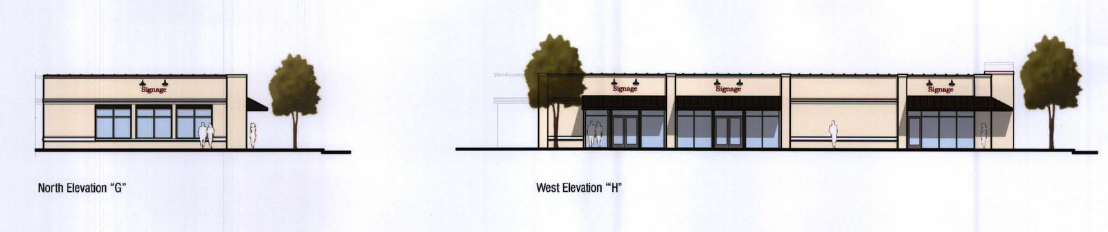
But not all is bad. Unlike the Harris Teeter itself, the site plans for the former George's Garage building on the corner of Ninth Street and Hillsborough show real promise. According to the site plans, the developers will transform a poorly designed, internally oriented and forbidding building into a far more open, inviting and pedestrian-friendly space, replacing the infamous blank wall facing Hillsborough with a patio and large windows. The new "Erwin Square Restaurant & Retail Center" is designed to house one or two restaurants and a small retail shop.

The  parking lot facing side of the building is much improved, with more windows, tree canopy and increased roof articulation. Compare the new design with the current design, featuring a huge blank wall on the south-west side of the building and ugly green yawing  throughout the rest.


 The east side is likewise much more inviting. As it stands now, it is a blank wall facing Ninth Street.

 Even the long suffering  Hillsborough side will get get some sprucing up. In particularly, the corner of Ninth and Hillsborough is gaining an attractive brick patio, which go a long way toward connecting visually Ninth Street to Vin Rouge and other businesses across the street on W. Markham.


Finally, the west side, which will be facing the new Harris Teeter, will also have some attractive windows and front-facing retail space. While this side will be overlooking parking, it is a huge improvement over another forbidding blank wall.

Monday, March 26, 2012

What is the Best Time to Sell Your House?


I think it is common wisdom that Spring is a good time to sell your house. Your realtors certainly think this way as evidenced by a sprouting of for-sale signs in our neighborhood every March/April. According to the folks at Trulia Trends, however,  the optimal time to sell your house varies depending on which region of the country you live in. While nationally prices peak in May, in our region, for example, the best time to sell is   earlier -- around March/April - this is when the prices peak and sellers can get the top dollar for their homes.

Read the entire analysis here, it is a fascinating read.


Saturday, March 24, 2012

New Juice Bar and Cafe coming to Ninth Street


If you have recently dined in Blue Corn Cafe on Ninth Street, you may have noticed a new addition to their kitchen in the form of Full Lotus, an all organic raw and vegan juice bar serving locally made smoothies, juices, salads and various vegan treets. The menu changes frequenly so the best way to find out what they are serving is to visit.

Yes, you can have one of these too
The folks behind Lotus hope to eventually find their own space on Ninth Street but, in the meantime, you can find them in the front of Blue Corn Cafe most afternoons (from 11:00 until 5:00 p.m.). 

Check out their website, like them on facebook, and visit them in person! Their smoothies are to die for.  


Wednesday, March 21, 2012

What is a safe neighborhood? How to use crime-mapping correctly

Once a week or so, I publish a report by RAIDS, an online tracking system used by Durham, that keeps track of all crime taking place within a one-mile radius of Ninth Street Shopping District. The latest of these reports, for example, shows that 29 criminal incidents took place in the area in the past 10 days. On the first brush, this sounds like a lot and, indeed, the RAIDS map of Durham shows our neighborhood in the shades of reddish yellow, which tends to indicate higher than normal crime rate.

Yet these statistics can be highly misleading. As good folks at Trulia have recently posted, just looking at the heat map of crimes tells you little about the relative safety of the area. The real question is not how much crime -- which is often dependent on the amount of commercial activity in the area -- but what kind 
of crime. When viewed through this lens, our area is a far cry from a criminal hotbed.

To illustrate, let's first take a look at the typical crime map of Durham's crime centered around Ninth Street. I took this data from Trulia Local

Looks bad, right? The red and the yellow colors denote high incidence of crime. But a surprising thing may jump out: Trinity Park, among the most affluent neighborhoods in Durham, is almost entirely colored in reddish/yellowish colors. But is this right? Most locals would argue that the area surrounding East Campus of Duke is fairly safe, a province of palatial homes of Duke faculty and expensive student housing. Indeed, when parsing through the data, one discovers that almost all of the incidents are related to partying as opposed to assaults. Similarly, the dark red areas enveloping Ninth Street Shopping District is theft related, which is unsurprising given the high volume of commercial activity going on there.

Now, let's take a look at the same map now showing the ratio of violent-to-nonviolent crimes. Here, we count crimes such as shootings and assaults as “violent” while petty crimes such as vandalism or theft are “nonviolent.”


Not much going on, particularly when compared to South-East and Central Durham which has seen an unfortunate rash of violence in the past year. 


To make comparison even more explicit, let's see a side-by-side of typical crime map of the two areas:

East Durham Crime Map
Although the East Durham map is redder, it is not dramatically different in color saturation. But what a contrast when the ratios of violent vs. non-violent crime are taking into account. As shown above, this ratio presents a far more  accurate picture of safety in an urban neighborhood.

Trinity Park Crime Map
As with most things in life, the simple and most "common sense" impressions are often wrong or incomplete. Just as one does not compare apples and oranges, one should not simply compare the crime level of a generic car-oriented suburban neighborhood to its urban counterpart. Instead, it is  
    imperative to look at what crime takes place and 
    whether this crime is an inherent outgrowth of 
    proximity to commerce or an indication of  
   something more sinister. 


Monday, March 19, 2012

Visual Pollution of Overhead Wires

This is a second post in a series that I am writing about the visual impact of overhead wires, the ways we can reduce that impact, and state and city regulations that govern this process. 

In my first post, I looked at the economics of burying overhead wires and the exorbitant price tag such a move would carry. I concluded that despite the cost -- at one point estimated by the NC Utilities Commission to be $42 billion statewide -- a gradual phase-in of underground infrastructure is desirable because it will increase reliability, preserve tree canopy and increase property values.      

In this post, I will look at the proliferation of unsightly overhead wires that has taken place in the past two decades and the visual impact it has on our city appearance.

A significant percentage of these wires are simply passing through the neighborhood, servicing the growing business and commercial interests in the areas around Ninth Street.  These cables are an eyesore, marring the beauty of our historic neighborhood.  They also interfere with the growth and care of existing trees and limit our ability to plant new trees.

Commonly found wires on NC utility poles
 Mess of wires on Iredell Street


You may be surprised to learn that most of these wires have nothing to do with  transporting electricity. Indeed, the wires that hang at the bottom of most utility poles are cable and telephone wires which Duke Power leases to Time Warner and Verizon at the expense of the taxpayers who are subsiding these leases through state-mandated rights-of-way.  As shown on the picture above, the electric utility companies place multiple non-electric wires on their poles.

The North Carolina Department of Transportation has specific rules that outline the minimal clearance for various types of wires. Their design guidelines are published below. Based on these rules, you may be surprised to learn that the minimum clearance for "joint users," meaning cable and telephone companies, and the ground is between 18 and 15 feet for most residential streets. The 18/15 foot gap is measured at the lowest point between the two poles - i.e. the point where the wire sags the most. Yet, admittedly unscientific inspection of two streets in the neighborhood -- Englewood and Green streets -- found many places where wires hang as low as 12 feet, creating potentially dangerous conditions while adding to the visual pollution of the street.

So what can we do about this? The first (and obvious) step is to enforce existing rules. Next, the NCDOT, which has jurisdiction over the placement and design of the poles, should consider a gradual phase in of more attractive and less intrusive utility pole designs. To mitigate the cost, perhaps the new rules will apply only to replacement poles. Overtime, this will lead to a much more visually pleasing cityscape. And given that according to the new poll only 41% of Durham residents are satisfied with the city's appearance, this is not an inconsequential concern.

A good place to start is this excellent article about overhead design and how utility poles can be made attractive and even distinctive with a little bit of creativity and effort.


Sunday, March 18, 2012

Widening of Erwin Road to Accommodate Hospital Expansion


The City and Duke University are cooperating to widen Erwin Road between the Eye Center and the Duke Hospital entrance to accommodate the addition of approximately one million square feet of hospital space following construction of the new cancer center and the Duke Medicine Pavilion.

Once the work is complete, there will be two additional turn lanes onto Fulton St. and new 6-foot sidewalks on both sides. The work is expected to be completed by the end of May.  A full description of the work, including the times when some of the lanes will be closed for construction, is reprinted after the break (courtesy of the Herald Sun).


From urban planning perspective, the idea of road widening is often controversial because of the "induced demand phenomenon" which postulates that building wider roads leads more people to drive on them, which, in turn, increases traffic and creates a vicious cycle of traffic congestion. An often-proposed solution to break this cycle is to increase availability of public transportation at the expense of private vehicles. For a thorough primer on the folly of mitigating traffic by widening roads read Traffic, an excellent book by Tom Vanderbilt, who is also a frequent contributor to Slate Magazine.  You can read his articles here.  Of particular interest -- and relevant to the current plans to add two extra left lanes to Erwin Rd -- is his excellent article about the folly of adding left lanes.


Saturday, March 17, 2012

New 984 area code coming to Durham on April 1


In another sign of explosive growth of the Triangle, the N.C. Utilities commission is adding a new area code -- 984 -- to accommodate the need for additional telephone numbers for the area currently served by the 919 code. Due to this change, startling on April 1, you will be required to use 10-digit dialing (area code + telephone number) to reach your intended party.

The full press release, curtesy of NC Utilities Commission, is embedded below.

Thursday, March 15, 2012

Harris Teeter on Ninth Street - images of the proposed design

The developers behind the proposed Harris Teeter on Ninth Street have had a rough few weeks. First, the neighborhood listservs exploded about the underhanded way in which the proposed development was filed with the City Planning Committee just a week before the new, more pedestrian friendly, city ordinance went into effect. In addition to lack of notice, people were upset about the car-centric suburban design of the store and how it will affect the character of the neighborhood.

Second, the Herald Sun followed up with less than flattering article about the Harris Teeter plan in which all the main stakeholders behind the plan summarily stonewalled the paper refusing to comment on any aspect of the development or design of the new store.

Next, a series of four letters to the editor excoriated Harris Teeter developers for failing to provide even the most basic urban amenities such as sidewalks, implement traffic calming measures, or work with the community on building a store that fits organically into the neighborhood cityscape.

In the meantime, the sign of HT's impending arrival has mysteriously disappeared. So what will the new store look like, assuming HT gets it way?

This is the areal view of the new store.
The front of the store will be overlooking Ninth Street across from a 200+ parking lot

The rear will be facing the existing Station Nine apartment complex, across the street from Erwin Sq.
The right side, which features some fake windows will be facing Hillsborough Road

The left side will overlook yet-to-be built Circle Nine Apartment Complex


Monday, March 12, 2012

Durham's Use of Public Transit Continues to Rise


The New York Times reports this morning that the rate of transit use in the U.S. continues to grow according to the report by American Public Transportation Organization (APTO), which has recently released its latest annual report.

Aside from national data, the report contains some interesting information about the overall growth of public transit ridership in. As detailed in the table below, the ridership increased by 13% from October 2010 to October 2011. In its press-release APTO specifically singled out Durham, along with the Triangle as a whole, as an sample of 2012 ridership increases. According to the press-release, the January saw a 15% increase in transit use in Durham.

Things are looking even better for the region as a whole. For the Triangle, the increase in ridership between October 2010 and October 2011 was at strong 16%. But the January 2012 growth was at a staggering 33.9%, with double digit increases every month they were tracking it.


To put all of these numbers perspective, consider that in large cities the bus ridership increased only by 0.4%  and the total transit use rose by 2.5%

This data should lend additional support and urgency to the need to implement light rail and other public transit solutions in the region. Durham has lead the way by passing the first transit referendum. And it leads North Carolina in transit use per capita. But now Orange and Wake counties must follow suit. And, if light and commuter rail is ever built, our neighborhood will be among its major beneficiaries because one of the major stations will be located just a short distance away from the Ninth Street Shopping District.

Here is to hoping that decision-makers in our and neighboring counties are drawing similar conclusions!